Cheongju Seongan-gil Fashion Street (청주 성안길)
2025-03-15
59 Sangdang-ro 59beon-gil, Sangdang-gu, Cheongju-si, Chungcheongbuk-do
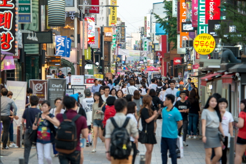
Located in the heart of Cheongju, Seongan-gil Fashion Street is known for its bustling fashion street, culture street, and car-free zone, where various shops, including clothing stores and restaurants, are gathered in one area. In addition, there are movie theaters, cafés, accessory shops, and a plaza, along with the Jungang Park and the Sangdang Park. The area is always lively, with street festivals and performances. It hosts various events, including flea markets and the Cheongju Cultural Heritage Night Tour.
Woosooyoung Tourist Attractions (우수영관광지)
2023-04-28
12, Gwangwang leisure-ro, Haenam-gun, Jeollanam-do
+82-61-530-5541
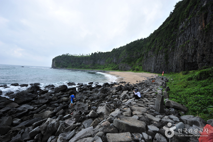
Woosooyoung Tourist Attractions area became a national tourist site in 1986, and Memorial Park of Admiral Yi was added in 1991, serving as an educational site. The area overlooks Uldolmok, and features a shrine from the past that commemorates the great victory that was achieved by Admiral Yi Sun-Sin in the Battle of Myeongnyang (1597) and a large geobukbae (turtle ship). The area hosts a history festival every October and covers many history-related experience programs throughout the year.
Zakyntos Global Spa Club - Cheongdam Main Branch (자킨토스 청담본점)
2025-01-14
537, Dosan-daero, Gangnam-gu, Seoul
+82-2-512-8967
Zakyntos is a world-wide spa franchise, having 13 different branches in Korea and 15 branches overseas, including in Bangkok, Pattaya and more. All stores are directly managed and supervised by the company headquarters, offering the best qualiity service to their
international clientele and keeping the brand's high standard in spa and other therapeutic experience programs.
Workers from nearby offices often frequent Zakyntos, as well as families and couples looking to relax. The clean and contemporary environment with professional therapists available 24/7, giving excellent stress-relief, are what make Zakyntos highly recommedable.
Haeundae Special Tourist Zone (해운대 관광특구)
2021-03-05
Haeundae-gu, Busan
+82-51-749-5700
Haeundae Beach in Busan is famous both in Korea and abroad. Not only is it popular as the largest summer vacation spot, but it also attracts people even in spring, autumn and winter for its variety of festivals and events, such as the Busan International Film Festival, the International Yacht Race and the Haeundae Sunrise Festival. These festivals help keep Haeundae busy as a popular tourist site all year round.
With Haeundae Beach at its center, Haeundae Special Tourist Zone offers diverse marine leisure activities and fresh seafood. The zone has transformed itself from a typical vacation spot into a destination where one can stay long-term while enjoying leisure activities and cultural events. Today, the zone attracts an increasing number of tourists from around the globe.
The zone not only has natural resources, such as Haeundae Beach, Dongbaekseom Island, Dalmaji Hill and sea water hot springs, but also a convention center and IT complex. Well-equipped with cultural facilities, including movie sets, art galleries and aquariums, it is a qualified destination for MICE (Meeting, Incentive tour, Convention and Exhibition) tourists.
The coastal drive course is another way to enjoy Haeundae Beach. Moontan Road, offering a grand night view and various walking trails, including Galmaet-gil lying along the coastline, should not be missed as well.
The skyline at Haeundae underwent a dramatic change with the advent of Centum City. At night, the city skyline that is brilliantly illuminated by the high-end residential/commercial buildings captivates travelers. Inside Centum City are luxury apartments and a grand shopping complex, including a department store and a retail outlet.
* Current State of Haeundae Special Tourist Zone
1) Districts Covered: Areas around Jung, Songjeong, Jaesong and U-dong (Centum City), Haeundae-gu, Busan
2) Area: 6,225,000 ㎡
* Tourist Attractions
Haeundae and Songjeong Beach, Dongbaek Island, Oryukdo Island, Centum City, Aquarium, Haeundae Hot Springs, etc.
Jongno Cheonggye Special Tourist Zone (종로 청계 관광특구)
2021-12-30
99, Yulgok-ro, Jongno-gu, Seoul
+82-2-2148-1861
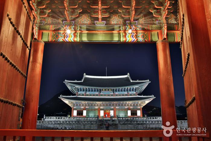
Jongno Cheonggye Special Tourist Zone stretches from Seorin-dong to Changsin-dong between Cheonggyecheon Stream and Jong-ro. It includes Youth Street, Gwangjang Market, Sewoon Electronics Department Store, lighting stores, pharmacy & medical device stores, badge stores, Stamp Street, Stationery · Toy Market, Aquarium Street, Shoes Market, and other markets totalling to approximately 14,000 shops. Nearby attractions include modern high-story buildings as well as Gyeongbokgung, Changdeokgung, Changgyeonggung, Deoksugung, and Unhyeongung Palaces, Jongmyo Shrine, and Insa-dong, merging traditions, modernism, culture, and markets alike.
Thought to be at the heart of Seoul, Cheonggyecheon Stream is located in the dense cultural area of Seoul where various press networks, organizations, bookstores and other major corporations are situated. Walking along Cheonggyecheon Stream is a famous activity for tourists. Also, the area is the venue for the Seoul Lantern Festival every winter. Keeping its traditional scene including narrow alleys, old-fashioned hanok buildings and various stores still fully intact, the tourist zone has enough fun places for sightseeing as well as tasty restaurants in every corner for a more enjoyable visit.
Jeju Island Special Tourist Zone (제주도 관광특구)
2025-05-20
Jeju-do
+82-64-740-6000
Located to the southwest of the Korean Peninsula, the island of Jeju is Korea's largest tourist destination. The entire island has been designated as a special tourist zone, and it's easy to see why: there is hardly any spot on the island that is not photogenic. Unlike mainland Korea, which has a temperate climate, Jeju boasts a climate that is closer to subtropical. Hallasan Mountain, lying at the center of the island, is surrounded by 368 parasitic cones, known as "Oreum." Eleven beaches have been designated as tourist beaches, but including those that are not officially designated, the island features nearly thirty beaches in total. Famous beaches include Iho Tewoo Beach, Samyang Beach, Hyeopjae Beach, Geumneung Beach, and Gwakji Beach. Jeju's renowned Olle Trails, a system of hiking paths, span a total length of 425 kilometers and would take about fifteen days to complete in their entirety.
Jeongeup Naejangsan Special Tourist Zone (정읍 내장산 관광특구)
2024-04-07
Naejang-dong, Jeongeup-si, Jeonbuk-do
+82-63-539-5193
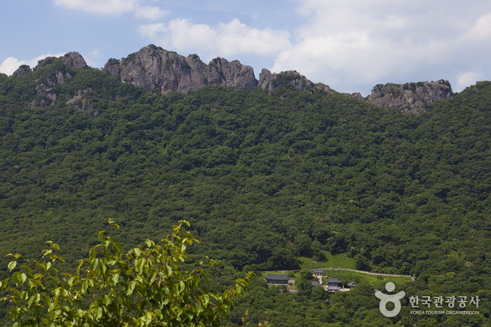
Jeongeup Naejangsan Special Tourist Zone, which covers Naejangsan Mountain, Baegamsan Mountain and Ibamsan Mountain, is known for the most beautiful fall scenery in Korea. In the autumn, the zone is aflame with autumnal tints. Naejangsan Mountain has been referred to as the “Geumgang of Honam” since the Joseon dynasty.
Naejangsan Mountain is about 11 kilometers away from downtown Jeongeup, and its name means "many secrets in the mountains." The highest peak of Naejangsan Mountain is Sinseonbong Peak, which is 763 meters above sea level. The nine peaks of the mountain stand in a circle, similar to the shape of a horse’s hoof. As one of the eight scenic views of the nation, it boasts grand scenery. Geumseongyegok Valley, which embraces Geumseonpokpo Falls, Dodeokpokpo Falls and Baegamgyegok Valley, is also famous.
Since there are more than ten trekking courses, hikers can choose a course after taking their physical stamina or personal preference into consideration. The length of each course varies from 1.5 to 14 kilometers. For those who are not able to trek long distances, walking the 3.6 kilometer-long nature trail that leads to the flatland is a good option. Visitors can reach the observation platform easily by riding a cable car from the ticket office.
The number of tourists has been steadily increasing since the KTX train began to stop at Jeongeup Station. When the autumn colors are at its peak in particular, taking the KTX makes the trip to Naejangsan Mountain much easier for travelers, and prevents traffic jams. The Donghak Peasants Revolution Commemoration is held in May and the Naejangsan Fall Foliage Festival takes place in October.
* Current State of Jeongeup & Naejangsan Special Tourist Zone
1) Districts Covered: Naejang Districts (Naejang and Ssangam-dong) and Yongsan Districts (Yongsan and Sinjeong-dong), Jeongeuop-si, Jeollabuk-do
2) Area: 3,448,365㎡
* Tourist Attractions
Naejangsan National Park, Okjeongho Lake, Jeongeupsa Park, Jeongeupcheon Stream, Chungyeolsa Shrine, Donghak Peasant Revolution Memorial Hall, etc.
Yuseong Special Tourist Zone (유성 관광특구)
2021-09-07
480, Daedeok-daero, Yuseong-gu, Daejeon
+82-42-611-2126
Daejeon is the center of state-of-the-art science and technology in Korea, where the nation’s top-tier venture enterprises, including Daedeok Special Research and Development Zone, run their businesses. As the representative city of science and technology for the nation, it is comparable to Silicon Valley in the United States.
Yuseong Special Tourist Zone, which is located in Daejeon Metropolitan City, has won a nationwide reputation as a tourism and resort district rich in hot springs and tourism resources. Yuseong Special Tourist Zone includes a hot springs water source that yields high quality water in copious streams; therefore, there is no need to dilute the water or raise the temperature.
With its healing effect proven, Yuseong Hot Springs has been the place for treatment and recuperation since the Three Kingdoms Period, and today, it is a popular travel destination for those seeking rest. The water is supplied to the hotels and other hot springs in the zone, and there are many restaurants serving a variety of dishes. There is also a facility where visitors can take a foot bath for free. Since Gyeryongsan National Park is near Yuseong-gu District, hikers take the opportunity to visit the nearby hot springs.
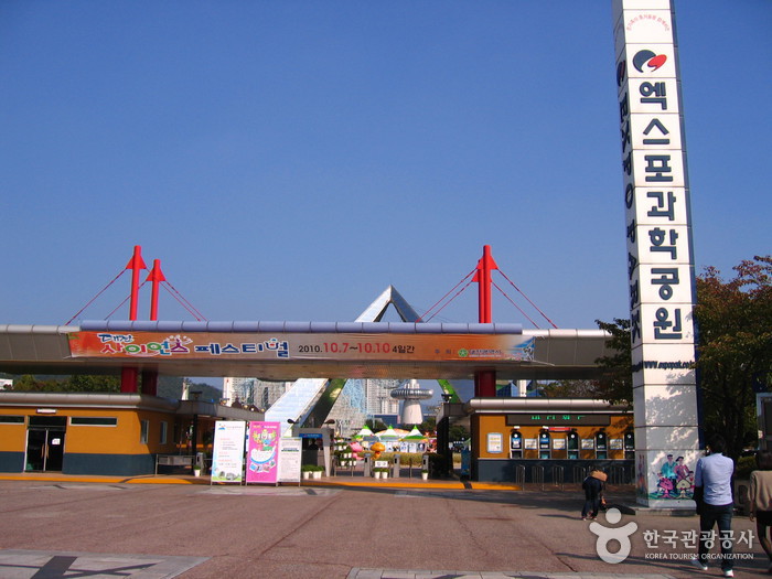
Science museums and pavilions, including Expo Science Park, around Yuseong Special Tourist Zone are popular destinations for families with children. Bordered by Gongju City which was the capital of Baekje during the period of Three Kingdoms, visitors can see the cultural heritage of Baekje.
* Current State of Yuseong Special Tourist Zone
1) Districts Covered: Areas around Yuseong Hot Springs and Expo Science Park (Jangdae, Guam, Gung, Eoeun, Doryong and Bongmyeong-dong, Yuseong-gu, Daejeon)
2) Area: 5,858,972 ㎡
* Tourist Attractions
Yuseong Hot Springs, Daedeok Science Complex, Kumdori Land, Expo Science Park, Art Museum, museums, ferry tour, amusement park, etc.

Jinjamhyanggyo Confucian School (진잠향교)
2022-12-26
67, Gyochon-ro, Yuseong-gu, Daejeon
+82-42-543-1811
Jinjamhyanggyo Confucian School was established to enshrine and orient the ancestral tablet of excellent classical scholars in 1405 (the 5th year of King Taejong's reign) and to educate people. More detailed information is not available in the record. The remaining building is called Daeseongjeon, and the ancestral tablets are 5 Seong, Songju 6 hyeon, and Korean 18 hyeon. One instructor, who received a plot of land and slaves from the nation, taught 30 students during the Joseon period, but after the Gapo Reform, the educational function disappeared and Seokjeon, a religious ceremony, was served in summer and fall with offerings of incense on the first day of each month and at the half-moon instead. Daeseongjeon (Cheongju Daeseong High School (Former Main Building of Cheongju Commercial High School) is designated as a Registered Cultural Heritage.
ARA Therapy (아라테라피)
2017-07-22
11-1, Baekbeom-ro, Mapo-gu, Seoul
+82-2-711-1176
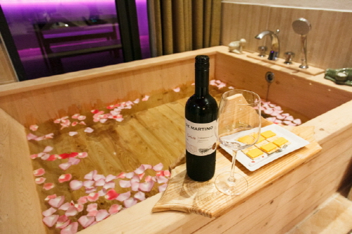
Ara Therapy offers excellent health care services and a cozy ambience at a reasonable price to all kinds of customers such as couples, family, and friends, regardless of age and gender. Services include foot-bathing and a free cup of healthy tea. Visitors can relieve their fatigue, listening to classical music at this comfortable resting area.
 English
 한국어
한국어 日本語
日本語 中文(简体)
 Deutsch
 Français
 Español
 Русский